Even as a non-Vancouverite I found this really interesting.
Great footage of Vancouver back in 1907, filmed by an individual that a few years later was on board the Titanic filming that voyage. He lost his life on that assignment.
[video][/video]
Re: Vancouver 1907
Posted: Sun Mar 17, 2013 1:14 pm
by KnowItAll
ahh yes, great memories.
I must be going senile though because I dont remember the streetcars and most of the other traffic driving on the oposite side of the street?
Re: Vancouver 1907
Posted: Sun Mar 17, 2013 5:12 pm
by cromartie
KnowItAll wrote:ahh yes, great memories.
I must be going senile though because I dont remember the streetcars and most of the other traffic driving on the oposite side of the street?
Pulling the answer straight from Wikipedia:
Canada drives on the right in LHD (left-hand-drive) vehicles, the largest land-area nation in the former British Commonwealth to do so. Until the 1920s, the rule of the road in Canada varied by province: British Columbia, New Brunswick, Nova Scotia, and Prince Edward Island had left-hand traffic, and the other provinces and territories had right-hand traffic. Starting on the west coast on 15 July 1920 and ending on the east coast on 1 May 1924, right-hand traffic was adopted uniformly throughout Canada.[36] Newfoundland was not part of Canada until 1949, and had left-hand traffic until 2 January 1947.[37]
Re: Vancouver 1907
Posted: Sun Mar 17, 2013 6:31 pm
by lfpeterson64
What a gift!
Re: Vancouver 1907
Posted: Sun Mar 17, 2013 9:15 pm
by TheLionKing
Nothing has changed, cyclists going the wrong way, people jaywalking
Re: Vancouver 1907
Posted: Mon Mar 18, 2013 4:03 pm
by notahomer
TheLionKing wrote:Nothing has changed, cyclists going the wrong way, people jaywalking
I noticed that too! There were sure a lot of bikes on that road. The horses didn't seem too spooked by the streetcar either. Neat piece of history.......
Re: Vancouver 1907
Posted: Mon Mar 18, 2013 7:04 pm
by sj-roc
I came across this interesting blog entry a couple months ago:
Apparently, False Creek back in those days extended farther east than its current limit near Science World. It went all the way to what is now Clark Drive, making the peninsula on which the downtown currently rests somewhat larger than it is today; in addition to the Granville and Cambie Bridges that span the creek there was also a Main Street Bridge at that time. This area was landfilled to its current shoreline profile just under a century ago. This was also around the time Pacific Central was built on Station St, a few blocks east of Science World; the fill-in to the west of this site, as seen in the photo below, was not yet completed.
According to one of the comments to this blog entry, it was originally proposed to have this creek fill-in extend westward all the way to the current site of Granville Island, which would have greatly limited the amount of waterfront condos developed in that area over the last couple of decades. The Bob Rennies of this city are probably wishing that that fill-in never happened.
Re: Vancouver 1907
Posted: Mon Mar 18, 2013 7:43 pm
by KnowItAll
sj-roc wrote:I came across this interesting blog entry a couple months ago:
Apparently, False Creek back in those days extended farther east than its current limit near Science World. It went all the way to what is now Clark Drive, making the peninsula on which the downtown currently rests somewhat larger than it is today; in addition to the Granville and Cambie Bridges that span the creek there was also a Main Street Bridge at that time. This area was landfilled to its current shoreline profile just under a century ago. This was also around the time Pacific Central was built on Station St, a few blocks east of Science World; the fill-in to the west of this site, as seen in the photo below, was not yet completed.
According to one of the comments to this blog entry, it was originally proposed to have this creek fill-in extend westward all the way to the current site of Granville Island, which would have greatly limited the amount of waterfront condos developed in that area over the last couple of decades. The Bob Rennies of this city are probably wishing that that fill-in never happened.
I miss the days when it was still the cnr station, before via rail, and before the bus station moved and before air travel became cheaper. I always enjoyed CN passenger over CP. Mid 70's I traveled between toronto and vancouver for less than 50$ by rail. Never knew that it was sitting on filled in creek.
Re: Vancouver 1907
Posted: Tue Mar 19, 2013 6:46 am
by Robbie
Another shorter clip from Vancouver 1907.
[video][/video]
Interesting how the city has evolved. In 1949:
[video][/video]
PNE in 1960.
[video][/video]
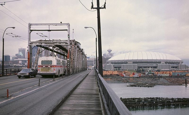
And a ride down Cambie Street and bridge in 1971 which includes footage of the old Cambie bridge that had a swing-span option in the middle of the bridge.
[video][/video]
I remember when the city decided to replace the bridge with a new one, residents were given the choice to vote whether the swing-span option would be kept in the new bridge. Residents voted unanimously against that option as it was a traffic hazard.
Who would have thought that a century later certain suburbs (e.g. Richmond) would be dominated by signage other than English, i.e. Chinese. Richmond City Council recently rejected a 1000-strong petition mandating the use of English or French on signage in the city. It looks like Chinese signage will only increase as the city evolves.